Cape’s Fort D Gets a D-Minus

Brother Mark and I woke up to temps in the low 40s Saturday. Even HE wasn’t ready to hit the road until the thermometer thawed out. He had to be in St. Louis for a concert in the evening, so we decided to do a short historical ride, starting in South Cape Girardeau.
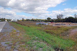
When I worked at The Southeast Missourian, South Cape was the euphemism we used for what everyone else in town called Smelterville (or, going back even more, Leadville). It was in the area of town that frequently flooded and was inhabited almost exclusively by poor black families.

While I was still in high school, I launched myself into a daring anthropological expedition to venture into Smelterville with my camera. If I wasn’t on the road, without access to them, I’d stick in some of those old pix. I think they stand up pretty well.

None of the dire things I had been warned about happened. Instead, I found myself and my camera being invited into homes and I discovered something that served me well throughout my whole newspaper career: most folks are pretty darned nice if you treat them with respect and dignity.
You can’t fight the river

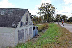
Old Man River took its toll over the years. More frequent and worse floods damaged many of the homes beyond repair; the roadbed passing through the community was raised and white flight to the suburbs opened up housing nearby that didn’t go under water. In 1996, after two “100-Year” floods in 1993 and 1995, many homes qualified for a government buyout program.

I didn’t see a single home in the area on this trip. Only the roof of this old furniture company sticks up above the roadbed.

I miss the Blue Hole
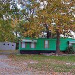
A green house trailer sits where the Blue Hole Restaurant used to serve up the best BBQ sandwiches in the area. I can remember going with my dad in his truck and wolfing down Brown Hots served on authentic Coca Cola metal trays.

The place was named after the limestone quarry next to it. When it filled with water, it looked like a Blue Hole.

Well, it sounded like a good idea
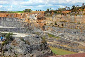
The quarry provided limestone for the Cape Cement Plant (since sold and renamed numerous times), once one of the largest employers in the area. Back before anyone ever thought about pollution control, the cement plant would billow out huge plumes of white dust that would cover everything for miles around.

The quarry started as a deep pit, and then was mined horizontally, leaving huge stone pillars to support the roofs. Back in the days of the Red Menace, I covered a city council meeting where it was discussed that those deep caverns would make a great fallout shelter.

How long can you hold your breath?

“Remember that they used to call that the Blue Hole because it fills with water if it’s not constantly being pumped out? How long do you think we could hide in those holes if the quarry filled up?” I asked innocently.

I never heard any mention of quarry-based fallout shelters again.

About 30 or 35 years ago, the pillars were blasted out and it changed to a deep pit quarry again. I managed to talk my way into the caverns to document them just before they were blown.

Everyone in Cape has heard of Fort D
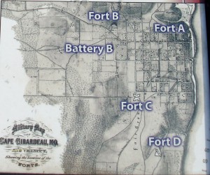
Nobody ever goes to see it, but they’ve heard about it. Larry J. Summary posted this image of Cape’s forts. Fort D is the only one that has survived.

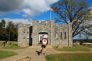
The site is nicely landscaped and the fort itself looks good until you notice that it has no roof.

Here’s an account good enough to borrow

Scott House, a retired teacher, and a member of the city’s Civil War Round Table, is leading an effort to interpret the fort’s history.
The forts were ordered built by Gen. John Fremont, the Western Department’s Union commander in St. Louis. Fremont dispatched a contingent of engineers to the town to lay out the forts. Assisting in the project was an officer, John Wesley Powell, who after the war would earn a name for himself exploring the Colorado River and the Grand Canyon.

Built in the summer of 1861, the four forts formed a crescent along the outskirts of town. House said a copy of an 1865 map drawn by Army engineers, now in the Library of Congress, provided a period look at the forts‚ dimensions and their proximity to the town. Continue reading “Cape’s Fort D Gets a D-Minus”

A Piece of Family History on Highway 61

I mentioned that my mother and I journeyed down Highway 61 while scouting out the New Madrid Earthquake bike route.

On the way south, we looked for a piece of property that my dad’s construction company owned in the late 50s.

Dad BUILT Route W

Steinhoff, Kirkwood and Joiner built roads and bridges all over Southeast Missouri in the 50s through the 70s. When I read Southeast Missourian Speak Out folks griping about cyclists on Route W, I think to myself, my dad BUILT Route W. I guess that gives me some right to ride on it.

Needed place to store equipment

Before long, SK&J needed a place to store equipment and a garage big enough to work on bulldozers and other earthmoving equipment.

They bought this land between Scott City and Benton and put up a mechanic’s shed / garage, a shed and several tool buildings.

Dad always wanted a big pond, so they built one on the property and stocked it with bass, crappie, blugills and catfish.

Water moccasins, turtles came on their own

I was an avid fly fisherman and loved to spend hours at the pond. The only bad thing was that you risked sharing your catch with the turtles and water moccasins.

I remember one day that dad and I had a huge stringer of fish we were looking forward to eating. One of us pulled up the stringer to add a new catch and discovered a good-sized moccasin hanging from it.

(1) It doesn’t take a Steinhoff long to look at a snake. (2) We decided that he wanted that stringer of fish more than we did.

We finally found it

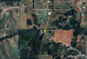
After passing by a couple of likely candidates, we doubled back to a property with a pond, a mobile home, a huge brick home and a hundred plastic Halloween pumpkins in front of it.

Jim Pinkston and his son, Jamie, 20, were picking up some limbs when we pulled up.

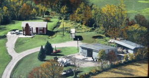
Jim knew right away what we were talking about and he was kind enough to share this colorized aerial photo taken shortly after his father built the house at left.

“My dad bought the property in 1969 or 1970. It included the garage, shed, some tool sheds, a loading dock and 7-1/2 acres of land with the pond,” Jim said.

“He had a trucking business, so the garage was a perfect shop for him,” he continued. They hauled Styrofoam sheets for Dow when it was in Cape. They used damaged sheets on the inside of the garage for insulation. Continue reading “A Piece of Family History on Highway 61”

New Madrid Earthquake Ride: No Great Shakes

Southeast Missourian webmaster James Baughn does a blog called Pavement Ends where he writes about interesting natural places to see in SE Missouri. His April 23, 2008, blog on the New Madrid Earthquake caught my eye.

Quakes are common

Little tremblors are common if you live in the area and predictions of The Next Big One come every decade or so. Kids hear about the New Madrid Earthquakes of 1811-1812 that caused the Mississippi River to flow backwards, changed the course of the river, created Reelfoot Lake and caused damage as much as 800 miles away.

James’ column mentioned a book, The New Madrid Fault Finders Guide, which costs a measly $16.95 (plus shipping).

It’s well worth the price if you are a history nut, interested in geology or watch reality TV about disasters.

I quickly found I wasn’t so much interested in reading about Pseudosesmic Landforms and Liquefaction as I was in learning that the Mississippi River used to run down the lowlands through Advance and Arkansas, with the junction of the Ohio and Mississippi Rivers being as far south as Natchez, MS, instead of Cairo, IL.

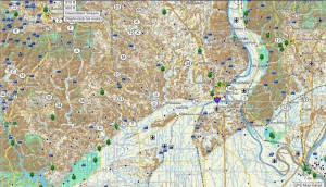
Makes sense when you look at a topo map

The Mississippi is the thin, blue line that’s meandering on the right side of the map. The lighter colors are the lowlands.

I had always heard that the high ridge that runs on the north side of 74 near Dutchtown was the old river boundary. Looks like the oldtimers were right.

What does this have to do with biking?

Seventy-seven pages into the  book, after addressing geology, history and neat disaster stuff, the authors produce the Interstate 55 Fault Finders Guide that will show you significant earthquake features on a mile marker by mile marker basis from roughly Scott City through Blytheville, AR. (They also point out that there is about a 30% chance of a small earthquake being recorded every day when you pass through this zone.)

OK, that’s great. But I can’t ride the interstate

The authors have six non-Interstate loops in the book. I picked the Benton-Sikeston Loop because it’s closest to home and put all the turns into my Garmin nüvi 760 GPS (full review). Because my mother always likes to go exploring, we hopped in her car and headed out on a scouting expedition.

Once you get to Scott City and get on Highway 61, the route is bikeable. I-55 has siphoned off most of the traffic, so I don’t think I’d feel uncomfortable on 61, even if it doesn’t have shoulders. Once you get past Benton and into Morley, the road has wide shoulders.

The backroads are good riding

The book takes you off on a bunch of side roads to look at specific land features. All of them were paved, in good condition and had hardly any traffic.

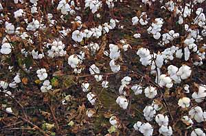
Fields of cotton will prove that the Missouri Bootheel is the Real South.

Will I bike this route?

No.

The roads are decent and there are interesting things to see, but most of it involves riding on flat roads with no shade. I get enough of that in South Florida.

Even with the guide book, I’m not enough of a geologist to appreciate the subtle changes in the environment to recognize the significance of what I’m seeing.

Still, even I am fascinated to read that the Sikeston Power Plant was built astride a major seismic fissure where the ground split open and quicksand flowed in.

My mother and I DID discover one thing that made the whole trip worthwhile. I’ll cover that later in the week.

I Left My Legs at Home

I set out this afternoon to do what Bro Mark and I call the Uncle Gus route because it goes past a farm owned by a distant relative. It was a great day for a ride: temps were in the low 80s, the sky was overcast and the winds were mild (but increasing).

My mother lives on the top of a hill, so you start out fast until you hit a barricade at the curve at the bottom of the street where there is road construction. It’s paved, so you can dodge the barrier.

The first, gradual climb went OK. I thought that I may have remembered how to do this after all.

Muscle memory

The muscle memory was there, all right. My muscles remembered that they get REALLY tired doing this.

Nothing around here has just one name. Depending on who you talk to, the road I was on is called Old Jackson Road (unless you’re in Jackson, where it’s called Old Cape Road), or Three Mile Creek Road (remember Cape LaCroix Creek from yesterday? Same creek.) On the map, it’s CR 620. At one time, it was the Houck Railroad.

Big rock went boom

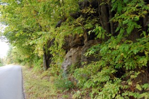
That brings us to this picture. Back in The Day, this was called the Houck Railroad Cut and was a path blasted through the limestone just big enough for a train to pass through. The railroad turned into a regular road and, in the 60s, my dad’s construction company was given the job to make the cut wider.

Someone misjudged the powder load and a huge boulder the size of a kitchen table was launched up, up, up until the law of gravity kicked in. It went right through the roof of a nearby house. No one was hurt, but it became part of family lore ever after.

The road has been widened again, so most folks who drive through there would never know to think of Louis Houck and his railroad.

What goes up comes down

If you check out the ride profile, you’ll see lots of pointy things. Those are hills. A lot of them are more than 12%.

It takes a lot longer to go UP those hills than it does to go down them. I stopped at the top of one of them to see that my GPS said I was at 524 feet above sea level. On the way down, I saw 37 mph on the speedometer. Unfortunately, when I finished coasting, I was at almost exactly 524 feet again and still had about another 150 feet of 12+% grade to climb. Continue reading “I Left My Legs at Home”

Cape LaCroix Recreational Trail Rings Cash Registers

I’m visiting my mother in Cape Girardeau, MO, a Mississippi River town halfway between St. Louis and Memphis.

I get back here at least once a year to recharge my psychic batteries in an area that has real hills, real trees and real people, all of which are sometimes in short supply in SFL.

Way back in the last century when I was a kid, Cape LaCroix Creek – known to locals as Three-Mile Creek – would overflow and flood homes and businesses every few years.

Got fed up with it

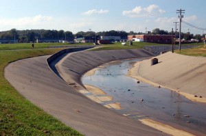
The Local Fathers got fed up with complaints from the wet folks and managed to scrape up enough money to make the creek run more efficiently and drain off the water before it spilled over its banks.

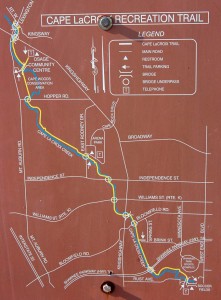
A side effect of that was the Cape LaCroix Recreational Trail, a 4.2-mile paved multiuse path, that was created next to the creek.

The trail starts (or ends, depending on your perspective) just down the hill from the old homestead, so I ride it several times when I visit. It’s fun meeting folks and it’s a great way to get from the north end of town to the south end without climbing a bunch of hills.

Arguably the most-used park in town

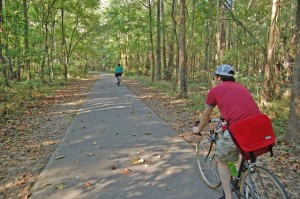
I’ve never been on it without meeting tens of bikers, roller bladers, joggers, walkers, families with strollers and dog walkers. I’ve often thought that it’s the most-used park in town, particularly if you define “use” as “actively participate” and not just “spectate.” It attracts all ages and demographic groups.

Other paths I’ve ridden seem to attract mostly local users: elderly folks who do short exercise rides in the evening, kids going to their friends’ houses or (on the Withlacoochee) an old guy who would walk to the convenience store with a small shopping cart to pick up the week’s supply of beer. I assumed this trail would be the same, especially since it’s so short.

Trail draws users for miles around

This afternoon I ran into a category of rider that local governments should take into consideration when people gripe about building public facilities like this one.

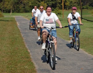
The first person I encountered was pulling a child’s trailer with a huge cooler and other stuff it in. When I got closer, I saw he had a toddler in a bike seat behind him. Up ahead was his wife with another toddler, a young girl and another adult couple.

They explained that they had driven to Cape from the Farmington, MO, area to ride the trail and have a picnic alongside it. Farmington is about an hour’s drive from Cape. Let’s review that: two families had loaded two cars with bicycles, snacks, toddlers as young as 18 months and driven close to 100 miles round trip so they could do a sub-10-mile bike ride because there weren’t any good facilities close at hand.

Cash registers were going to ring

Oh, yeah, and while they were in Cape primarily to ride their bikes, they were also going to do some shopping.

[Editor’s note: I am horribly embarrassed to admit that I stuck a digital recorder under their noses and very carefully recorded every name so I could mention them. Unfortunately, Murphy was riding along with me and ate the info. The only name I can remember was 8-year-old Kendra who thought riding was “good excercise and a lot of fun, but I think it might make me lose too much weight.”]

Not the only one

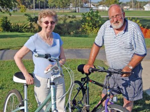
I would have thought they were an anomaly until I found the Cerneys who drove 30 miles from Illinois to ride the trail. The said that they had often seen riders on the trail when they came into Cape for shopping and they decided to bring their bikes along for a ride.

After giving their names, Mr. Cerney asked, “Don’t you want our ages?”

“Sure,” I replied. “I just didn’t think it was polite to ask.”

“I’m 72 and Jane is 71,” he said. (I should be drinking what they’re drinking.)

Finally, local riders

On the way back home, I ran into the Schroeders just as they were entering the Cape Woods Conservation Area on their way to the Osage Center to watch her brother play flag football. They thought they’d take their bikes since it was such a nice afternoon.

Well maintained

The Cape area has had several flash floods this year that  put the trail under some raging waters. I was curious to see if there would still be debris, rocks and gravel across it. It was spotless. Part of the credit goes to the local bicycle club which conducts periodic cleanup sessions.

This just goes to show that parks don’t have to have expensive lights and facilities to attract a large number of users, some from out of town with money to spend to bolster the local economy.

The only negative I can see is the local Letters to the Editor Yahoos who gripe, “Why are people riding their bikes in the street when we built them that nice bike path.”